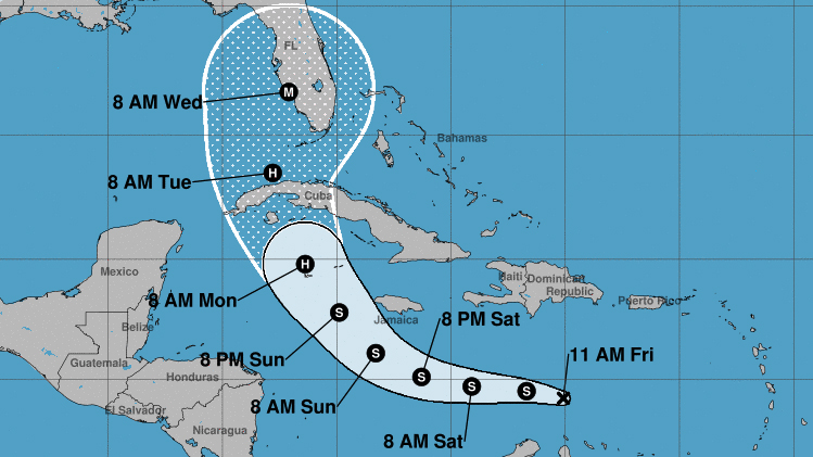
Miami – According to the National Hurricane Center (NHC), Tropical Storm Ian, formerly Tropical Depression 9, formed this Friday over the central Caribbean Sea. Parts of Cuba and the entire state of Florida are under the trajectory cone.
According to him The latest NHC bulletin was released at 11:00 p.m As of Friday, the system was 385 miles southeast of Kingston, Jamaica, and 680 miles east-southeast of Grand Cayman Island.
According to the NHC, the tropical storm has sustained winds of 40 mph and is moving west-northwest at 12 mph.
According to NHC forecasts, the hurricane will move through the Caribbean on Saturday, pass south of Jamaica between Saturday night and Sunday and approach the Cayman Islands between Sunday night and Monday morning.
After becoming a tropical storm tonight, it is expected to strengthen into a hurricane on Monday.
Notices, watches and warnings are in effect
A tornado watch is in effect
A tropical storm watch is in effect
During this time, the system is expected to drop 2 to 4 inches of rain, with maximum accumulations of 6 inches, over southern Haiti and the Dominican Republic; 6 to 10 inches in western and central Cuba, with a maximum of 14 inches. Heavy rain is expected to start falling in South Florida on Monday.
Our meteorologist Pedro Montoro explains the formation and intensification of a hurricane step by step from the virtual lab.
The cyclone is also expected to leave strong waves and cause dangerous storm surge.


