
Within 48 hours of its formation being detected, the potential tropical cyclone finally developed in the Gulf of Mexico and became the first potential tropical cyclone. Tropical Storm “Alberto” is the first hurricane of the 2024 season. The storm has been classified as a “very large system with rainfall, flooding in coastal areas, and wind impacts.”
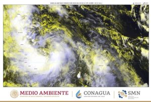
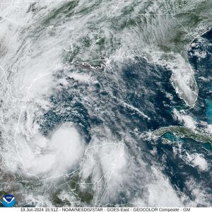
Satellite images captured by Zoom Earth It reveals what the eye of this phenomenon looks like from space, providing perspective Impressive in its size and displacement.
he National Weather Service He noted that Alberto had become a tropical storm around 9:00 a.m. on Wednesday, June 19. The phenomenon Its movement speed increased slightly over the Gulf of Mexico, Generating sustained winds of 65 kilometers per hour and an atmospheric pressure of 995 hectopascals.
Tropical storm #Alberto It formed over the western Gulf of Mexico. Latest satellite views 🛰️ pic.twitter.com/j8cARGJUIB
—Zoom Earth (@zoom_earth) June 19, 2024
Impact on Mexican entities
Zoom Earth images clearly show the structure of the storm, highlighting the eye of the hurricane as it moves across the Gulf of Mexico. This storm severely affects Mexican entities near the coast, including… Yucatan, Campeche, Tabasco, Veracruz, Tamaulipas, Monterrey, Coahuila and Chiapas. Local authorities issued warnings of the possibility of floods and strong winds in these areas.
Speculation and expected changes from “Alberto”
Tropical Storm Alberto's wind speeds are expected to increase to 75 km/h around 6:00 PM today, and it is expected to reach It will make landfall Wednesday night on the border of Tamaulipas and VeracruzMaintaining this intensity until the morning of June 20.
However, for this Thursday at 6:00 PM, Alberto is expected to weaken, leaving a remnant of low pressure. It is important to note this The development and path of the storm is variableTherefore, forecasts may change within the next few hours.
Observation from space of the eye of a hurricane
Images obtained from space provide a clear view of Alberto's size and composition. These images are not only vital for monitoring and analyzing the phenomenon, But also highlighting the importance of satellite technology in natural disaster management. The ability to monitor and monitor the storm in real time allows authorities and residents to be better prepared to deal with its effects.